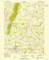
1953 Map of Purcellville
USGS Topo · Published 1953About this map
The Short Hill ridge dominates the western edge of this Loudoun County landscape, overlooking a series of agricultural communities and rail-linked towns in the early 1950s. The Washington and Old Dominion railroad serves as the primary corridor for commerce, connecting Purcellville and Hamilton, with a notable stop at Hamilton Sta. The rural character of the area is defined by numerous small settlements like Morrisonville and Wheatland, while several country churches, including Arnold Grove Ch, Ketoctin Ch, and Mt Olive Ch, mark the social hubs of the era. Extensive water networks, primarily the North Fork and South Fork of Catoctin Creek, snake through the valley floor, supporting historic mill sites such as Milltown. This survey captures the transition of the region from a strictly agrarian economy toward more recreational developments, as evidenced by the Loudoun County Country Club.
Find a feature on this map
30 named features on this map. Tap any name to fly to it.
Don’t see what you’re looking for? This feature index may not catch every label — zoom into the map to look around manually.
Map Details
Editions of this 1953 Purcellville Map
This is the sole edition of this map. No revisions or reprints were ever made.
Other maps of this area

1884 · Harpers Ferry
USGS Topo · 1:125,000

1891 · Harpers Ferry
USGS Topo · 1:125,000

1893 · Harpers Ferry
USGS Topo · 1:125,000

1908 · Middletown
USGS Topo · 1:48,000

1910 · Antietam
USGS Topo · 1:62,500

1914 · Martinsburg
USGS Topo · 1:48,000

1916 · Martinsburg
USGS Topo · 1:62,500

1916 · Berryville
USGS Topo · 1:62,500

1939 · Berryville
USGS Topo · 1:48,000

1943 · Bluemont
USGS Topo · 1:24,000