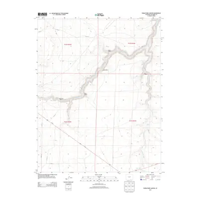
2013 Map of Purgatoire Canyon
USGS Topo · Published 2013About this map
Los Hermanos Penitentes Cem sits as a significant cultural marker on the high ground overlooking the deep cut of Purgatoire Canyon. The landscape is dominated by the meandering Purgatoire River, which has carved a dramatic series of bends and side canyons into the Las Animas County terrain, including Miller Canyon and Perea Canyon. This high desert environment is punctuated by vital water sources such as the Million Dollar Water Hole, Rail O Spring, and Surratt Spring. Further south, the map details the descent toward Trinchera Cr and its notable Trinchera Falls. The road network, including Us-160 and various county routes like Co Road 113, demonstrates how modern infrastructure navigates the complex topographical breaks of the canyon country while following the natural drainage patterns of the Salt Cr valley.
Find a feature on this map
25 named features on this map. Tap any name to fly to it.
Don’t see what you’re looking for? This feature index may not catch every label — zoom into the map to look around manually.
Map Details
Editions of this 2013 Purgatoire Canyon Map
This is the sole edition of this map. No revisions or reprints were ever made.
Other maps of this area

1891 · Mesa De Maya
USGS Topo · 1:125,000

1892 · Elmoro
USGS Topo · 1:125,000

1893 · Elmoro
USGS Topo · 1:125,000

1893 · Mesa de Maya
USGS Topo · 1:125,000

1897 · Elmoro
USGS Topo · 1:125,000

1954 · Trinidad
USGS Topo · 1:250,000

1955 · La Junta
USGS Topo · 1:250,000

1955 · Trinidad
USGS Topo · 1:250,000

1958 · La Junta
USGS Topo · 1:250,000

1958 · Trinidad
USGS Topo · 1:250,000