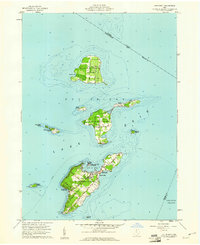
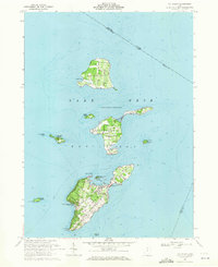
1959 Map of Put-In-Bay
USGS Topo · Published 1961About this map
Put-in-Bay serves as the central hub of this island archipelago in Lake Erie, captured at the close of the 1950s. The village is dominated by the Perry Nat Monument, while nearby St Pauls Ch and local schools anchor the community on South Bass Island. The map illustrates a landscape of orchards and vineyards, particularly on North Bass Island near the settlement of Isle St George and around Middle Bass Island.
Find a feature on this map
50 named features on this map. Tap any name to fly to it.
Don’t see what you’re looking for? This feature index may not catch every label — zoom into the map to look around manually.
Map Details
Editions of this 1959 Put-In-Bay Map
This is the sole edition of this map. No revisions or reprints were ever made.
Other maps of this area

1901 · Put-In-Bay
USGS Topo · 1:62,500

1903 · Put In Bay
USGS Topo · 1:62,500

1916 · Kelleys Island
USGS Topo · 1:62,500

1919 · Kelleys Island
USGS Topo · 1:62,500

1956 · Toledo
USGS Topo · 1:250,000
1959 · Port Clinton
USGS Topo · 1:24,000
1959 · Gypsum
USGS Topo · 1:24,000
1959 · Kelleys Island
USGS Topo · 1:24,000

1961 · Toledo
USGS Topo · 1:250,000
1969 · Put-In-Bay
USGS Topo · 1:24,000