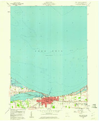
1959 Map of Port Clinton
USGS Topo · Published 1960About this map
Port Clinton and the industrial hamlet of Gypsum occupy the southern shore of Lake Erie where the Portage River meets the lake. This mid-century survey reveals a thriving lakeside community organized around the New York Central railroad corridor and the Village Boundary. Notable civic infrastructure includes the Courthouse, City Hall, and Magruder Hospital, while education is anchored by High School and the Bataan Memorial School.
Find a feature on this map
26 named features on this map. Tap any name to fly to it.
Don’t see what you’re looking for? This feature index may not catch every label — zoom into the map to look around manually.
Map Details
Editions of this 1959 Port Clinton Map
This is the sole edition of this map. No revisions or reprints were ever made.
Other maps of this area

1900 · Oak Harbor
USGS Topo · 1:62,500

1901 · Put-In-Bay
USGS Topo · 1:62,500

1901 · Bellevue
USGS Topo · 1:62,500

1901 · Fremont
USGS Topo · 1:62,500

1903 · Bellevue
USGS Topo · 1:62,500

1903 · Fremont
USGS Topo · 1:62,500

1903 · Put In Bay
USGS Topo · 1:62,500

1952 · Lacarne
USGS Topo · 1:24,000

1952 · Oak Harbor
USGS Topo · 1:62,500

1956 · Toledo
USGS Topo · 1:250,000