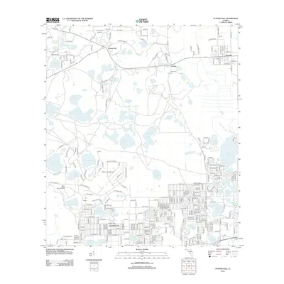
2012 Map of Putnam Hall
USGS Topo · Published 2012About this map
Putnam Hall and Grandin serve as the primary hubs for this lake-strewn portion of Florida, where the landscape is defined by dozens of freshwater bodies and wetlands like Goodson Prairie. The settlement pattern reflects a mix of established villages and later developments like Oak Ridge Park, which shows a dense grid of residential streets south of Lake Lucy. Aviation history is present at Melrose Landing Airport, while the Baden-Powell Scout Reservation occupies the shoreline of Lake Loyal. For those tracing local roots, the map identifies several burial grounds including Abline Cem and Pineview Cem. The geography is remarkably porous, with larger waters like Swan Lake and Lake Grandin connected by a network of smaller ponds and lakes such as Flamingo Lake and Mariner Lake, illustrating the unique hydrology of the interior peninsula.
Find a feature on this map
315 named features on this map. Tap any name to fly to it.
Don’t see what you’re looking for? This feature index may not catch every label — zoom into the map to look around manually.
Map Details
Editions of this 2012 Putnam Hall Map
This is the sole edition of this map. No revisions or reprints were ever made.
Other maps of this area

1915 · Interlachen
USGS Topo · 1:48,000

1916 · Interlachen
USGS Topo · 1:62,500

1938 · Hawthorn
USGS Topo · 1:48,000

1941 · Starke
USGS Topo · 1:62,500

1942 · Ates Creek
USGS Topo · 1:62,500

1943 · Hawthorn
USGS Topo · 1:62,500

1944 · Interlachen
USGS Topo · 1:62,500

1948 · Starke
USGS Topo · 1:50,000

1949 · Rice Creek
USGS Topo · 1:24,000

1949 · Keuka
USGS Topo · 1:24,000