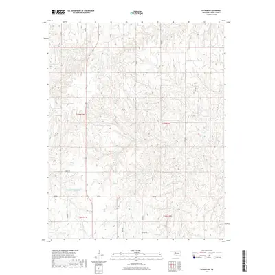
2018 Map of Putnam NW
USGS Topo · Published 2018About this map
Fairview Cem sits at a crossroads in the southeastern portion of this Dewey County landscape, serving as a quiet focal point for the surrounding rural community. The area is defined by a dense network of sectional roads, including n2280 RD and e0770 RD, which navigate the undulating terrain between various watercourses. Significant water management is evident at the Boggess-Erosion Control Number 1 Reservoir, a prominent feature that highlights local efforts to manage the drainage into Sorter Cr. Further north, Trail Cr carves through the eastern sections, while Highway 183 provides the primary north-south corridor for the region. The map reveals a land divided into clear legal townships such as t17n r17w and t16n r16w, reflecting the enduring structure of Oklahoma's land survey system and the importance of localized agricultural infrastructure.
Find a feature on this map
24 named features on this map. Tap any name to fly to it.
Don’t see what you’re looking for? This feature index may not catch every label — zoom into the map to look around manually.
Map Details
Editions of this 2018 Putnam NW Map
This is the sole edition of this map. No revisions or reprints were ever made.
Other maps of this area

1955 · Clinton
USGS Topo · 1:250,000

1955 · Woodward
USGS Topo · 1:250,000

1957 · Clinton
USGS Topo · 1:250,000

1958 · Woodward
USGS Topo · 1:250,000

1962 · Putnam
USGS Topo · 1:62,500

1962 · Aledo
USGS Topo · 1:62,500

1969 · Lenora
USGS Topo · 1:24,000

1972 · Hucmac
USGS Topo · 1:24,000
1972 · Taloga
USGS Topo · 1:24,000

1984 · Foss Reservoir
USGS Topo · 1:100,000