
1972 Map of Hucmac
USGS Topo · Published 1974About this map
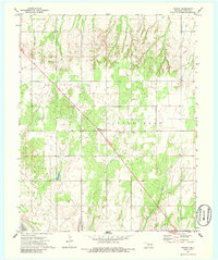
Hucmac sits at the center of this rural Oklahoma landscape during the early 1970s, where the high plains terrain of Dewey County is deeply dissected by the drainage of Little Robe Creek. This creek system winds southward toward the Canadian River, which cuts across the far southwestern corner of the quadrangle. The map reveals a sparsely populated agricultural and energy-producing region, evidenced by the broad Oil Field designation in the northeast and scattered oil wells along the draws. Local community life is anchored by the Church of Christ and the Monice Cemetery, while the larger boundary of Taloga is indicated to the west. The survey provides a clear view of the section-line road network that defines the rural geometry of the Little Robe area, showing how topography and township lines dictated the placement of homesteads and infrastructure.
Find a feature on this map
10 named features on this map. Tap any name to fly to it.
Don’t see what you’re looking for? This feature index may not catch every label — zoom into the map to look around manually.
Map Details
Editions of this 1972 Hucmac Map
2 editions found
Other maps of this area

1955 · Clinton
USGS Topo · 1:250,000

1955 · Woodward
USGS Topo · 1:250,000

1957 · Clinton
USGS Topo · 1:250,000

1958 · Woodward
USGS Topo · 1:250,000

1962 · Putnam
USGS Topo · 1:62,500

1964 · Oakwood
USGS Topo · 1:62,500

1972 · Canton NW
USGS Topo · 1:24,000

1972 · Canton SW
USGS Topo · 1:24,000

1972 · Seiling
USGS Topo · 1:24,000
1972 · Taloga
USGS Topo · 1:24,000