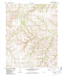
1985 Map of Putnam NW
USGS Topo · Published 1985About this map
Taloga Oil and Gas Field and the Dawson Oil Field dominate the landscape of northwestern Oklahoma in the mid-1980s, revealing an era of intensive energy extraction across Dewey County. The terrain is marked by a high density of Gas Wells, Oil Wells, and numerous Drill Holes, reflecting the subsurface industrial wealth of the region. This economic activity is supported by a network of infrastructure including a prominent Pipeline and the north-south corridor of Route 183. At the local level, the map identifies landmarks of rural life such as the Fairview Cemetery and the Dawson benchmark. Waterways like Sarter Creek cut through the undulating plains, while smaller features such as a Gravel Pit and a Radio Tower provide specific points of reference for those tracing historical land use or genealogical ties to the Harrison and Banner Oil Field areas.
Find a feature on this map
18 named features on this map. Tap any name to fly to it.
Don’t see what you’re looking for? This feature index may not catch every label — zoom into the map to look around manually.
Map Details
Editions of this 1985 Putnam NW Map
This is the sole edition of this map. No revisions or reprints were ever made.
Other maps of this area

1955 · Clinton
USGS Topo · 1:250,000

1955 · Woodward
USGS Topo · 1:250,000

1957 · Clinton
USGS Topo · 1:250,000

1958 · Woodward
USGS Topo · 1:250,000

1962 · Putnam
USGS Topo · 1:62,500

1962 · Aledo
USGS Topo · 1:62,500

1969 · Lenora
USGS Topo · 1:24,000

1972 · Hucmac
USGS Topo · 1:24,000
1972 · Taloga
USGS Topo · 1:24,000

1984 · Foss Reservoir
USGS Topo · 1:100,000