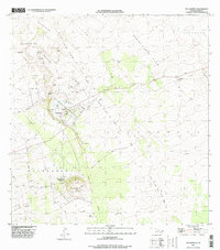
1996 Map of Puu Anahulu
USGS Topo · Published 1998About this map
Lava Flow of 1859 dominates this landscape, carving a wide path across the terrain of the Big Island. This survey details the complex geological and cultural history of the North Kona region during the mid-1990s. The Puu Anahulu Homesteads provide a clear view of early Hawaiian land divisions and agricultural settlement patterns, centered near the small community of Puuanahulu. Scattered through the lava fields and upland areas are traditional landmarks and ranching sites, including the Puu Waawaa Ranch and the prominent cinder cone of Puu Waawaa. The map documents numerous long-standing rock walls, reflecting generations of land management and property boundaries. Other notable features like the Kaniku Lava Flow and various family-named pu'u (hills) such as Puu Kukai and Puu Haole highlight the indigenous geographic naming conventions that define this volcanic region.
Find a feature on this map
37 named features on this map. Tap any name to fly to it.
Don’t see what you’re looking for? This feature index may not catch every label — zoom into the map to look around manually.
Map Details
Editions of this 1996 Puu Anahulu Map
2 editions found
Other maps of this area

1927 · Kaohe
USGS Topo · 1:62,500

1928 · Puako
USGS Topo · 1:62,500

1928 · Kailua
USGS Topo · 1:62,500

1930 · Kaohe
USGS Topo · 1:62,500

1954 · Hawaii North
USGS Topo · 1:250,000

1956 · Puu Hinai
USGS Topo · 1:24,000

1956 · Keamuku
USGS Topo · 1:24,000

1956 · Nohonaohae
USGS Topo · 1:24,000

1956 · Naohueleelua
USGS Topo · 1:24,000

1959 · Hawaii North
USGS Topo · 1:250,000