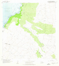
1956 Map of Puu Hinai
USGS Topo · Published 1975About this map
Kaniku Lava Flow dominates this coastal landscape along Kawaihae Bay, revealing the raw volcanic character of the South Kohala District in the mid-1950s. The small coastal settlement of Puako sits at the edge of the lava, near numerous protected inlets and fishponds that define this section of the shore. Traditional Hawaiian land management is evident in the cluster of ponds including Keanapou Fishpond, Waipuhi Fishpond, and Hopeala Fishpond located near Lahuipuaa.
Find a feature on this map
46 named features on this map. Tap any name to fly to it.
Don’t see what you’re looking for? This feature index may not catch every label — zoom into the map to look around manually.
Map Details
Editions of this 1956 Puu Hinai Map
3 editions found
Other maps of this area

1913 · Kohala
USGS Topo · 1:62,500

1916 · Kohala
USGS Topo · 1:62,500

1916 · Waipio
USGS Topo · 1:62,500

1928 · Puako
USGS Topo · 1:62,500

1954 · Hawaii North
USGS Topo · 1:250,000

1956 · Puu Hinai
USGS Topo · 1:24,000

1956 · Kamuela
USGS Topo · 1:24,000

1956 · Keamuku
USGS Topo · 1:24,000

1956 · Nohonaohae
USGS Topo · 1:24,000

1956 · Kawaihae
USGS Topo · 1:24,000