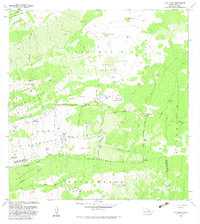
1982 Map of Puu Lehua
USGS Topo · Published 1982About this map
Puu Lehua Ranch sits at the heart of this upland terrain on the Island of Hawaii, where volcanic geology and ranching history converge. The landscape is defined by extensive lava flows and kipukas—pockets of older vegetation spared by more recent flows—such as Kipuka Paluli and Lupea Kipuka. In an area famously labeled Devil Country, the map reveals the ingenious water management required for high-elevation ranching, evidenced by numerous Water Tanks and specialized structures like the Rain-Shed Water Tanks. Local heritage is preserved through former habitation markers, including the Kahelepo House (Site) and Nahaina (Site). The terrain transitions through various tracts such as Lehuula Mauka Tract and Hokukano Mauka Tract, following the boundary line between the North Kona and South Kona Districts.
Find a feature on this map
49 named features on this map. Tap any name to fly to it.
Don’t see what you’re looking for? This feature index may not catch every label — zoom into the map to look around manually.
Map Details
Editions of this 1982 Puu Lehua Map
2 editions found
Other maps of this area

1927 · Kaohe
USGS Topo · 1:62,500

1928 · Kailua
USGS Topo · 1:62,500

1928 · Mauna Loa
USGS Topo · 1:62,500

1930 · Kaohe
USGS Topo · 1:62,500

1954 · Hawaii South
USGS Topo · 1:250,000

1954 · Hawaii North
USGS Topo · 1:250,000

1956 · Puu O Uo
USGS Topo · 1:24,000

1956 · Naohueleelua
USGS Topo · 1:24,000

1959 · Hawaii South
USGS Topo · 1:250,000

1959 · Hawaii North
USGS Topo · 1:250,000