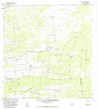
1982 Map of Puu Lehua
USGS Topo · Published 1984About this map
The high slopes of the North and South Kona Districts are captured here in the early 1980s, revealing a landscape defined by volcanic geology and ranching history. High-elevation kipukas—pockets of older land surrounded by more recent flows—provide distinct ecological and geographical markers, including Kipuka Paluli, Mizotas Kipuka, and Waiio Kipuka. These features, along with the notable Devil Country, show the island's raw terrain before significant modern development. Cultural history is present in the form of ranching outposts and former habitations, such as the Puu Lehua Ranch and the Kahelepo House (Site). The map records a network of four-wheel-drive tracks and trails connecting isolated corrals, water tanks, and naming conventions that reflect traditional land divisions like the Lehuula Mauka Tract and Hokukano Mauka Tract.
Find a feature on this map
57 named features on this map. Tap any name to fly to it.
Don’t see what you’re looking for? This feature index may not catch every label — zoom into the map to look around manually.
Map Details
Editions of this 1982 Puu Lehua Map
2 editions found
Other maps of this area

1927 · Kaohe
USGS Topo · 1:62,500

1928 · Kailua
USGS Topo · 1:62,500

1928 · Mauna Loa
USGS Topo · 1:62,500

1930 · Kaohe
USGS Topo · 1:62,500

1954 · Hawaii South
USGS Topo · 1:250,000

1954 · Hawaii North
USGS Topo · 1:250,000

1956 · Puu O Uo
USGS Topo · 1:24,000

1956 · Naohueleelua
USGS Topo · 1:24,000

1959 · Hawaii South
USGS Topo · 1:250,000

1959 · Hawaii North
USGS Topo · 1:250,000