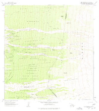
1963 Map of Puu Pohakuloa
USGS Topo · Published 1977About this map
The South Kona Forest Reserve dominates this high-elevation landscape on the Big Island, where historical land divisions and volcanic activity shape the terrain. Extensive lava flows from 1950, 1919, and earlier cross the slopes, cutting through traditional land units like Honokua and Kaapuna. High-altitude ranching and settlement patterns are evident at Kaohe Ranch and Hopper Camp, while the Haukalua 2 Homesteads and Kukuiopae Homesteads mark earlier efforts at organized habitation. Essential water sources for the region's cattle and inhabitants are carefully noted, including Lumiawai Waterhole and various Rain Sheds. The map provides a look at the boundary between the South Kona and Kau Districts, following a line that passes the cinder cone of Puu Pohakuloa.
Find a feature on this map
46 named features on this map. Tap any name to fly to it.
Don’t see what you’re looking for? This feature index may not catch every label — zoom into the map to look around manually.
Map Details
Editions of this 1963 Puu Pohakuloa Map
2 editions found
Other maps of this area

1924 · Honuapo
USGS Topo · 1:62,500

1928 · Mauna Loa
USGS Topo · 1:62,500

1928 · Hoopuloa
USGS Topo · 1:62,500

1954 · Hawaii South
USGS Topo · 1:250,000

1959 · Hawaii South
USGS Topo · 1:250,000

1959 · Honaunau
USGS Topo · 1:24,000
1960 · Kaunene
USGS Topo · 1:24,000

1961 · Hawaii South
USGS Topo · 1:250,000

1962 · Hawaii South
USGS Topo · 1:250,000

1962 · Milolii
USGS Topo · 1:24,000