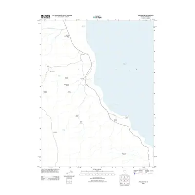
2011 Map of Pyramid SW
USGS Topo · Published 2011About this map
Pyramid Lake dominates the eastern horizon of this high-desert landscape in northwestern Nevada. The western shoreline is deeply indented by natural features such as Wizards Cove, Thunderbolt Bay, and Ninemile Bay. On land, the settlement of Pyramid sits near the mouth of Big Canyon, where the Big Canyon Ranch Rd provides access to the Big Canyon Ranch. The terrain is defined by a series of steep drainages, including Sharps Canyon, Thunderbolt Canyon, and Jigger Bobb Canyon, all carving their way toward the lake's edge. This 2011 survey captures the area's essential water sources in an arid environment, noting Barrel Spring and Hornet Spring. Notable landmarks along the water's edge include the distinctively named George Washington Rock at the north and Warrior Point to the south.
Find a feature on this map
23 named features on this map. Tap any name to fly to it.
Don’t see what you’re looking for? This feature index may not catch every label — zoom into the map to look around manually.
Map Details
Editions of this 2011 Pyramid SW Map
This is the sole edition of this map. No revisions or reprints were ever made.
Other maps of this area

1886 · Granite Range
USGS Topo · 1:250,000

1891 · Reno
USGS Topo · 1:125,000

1893 · Reno
USGS Topo · 1:125,000

1894 · Granite Range
USGS Topo · 1:250,000

1955 · Lovelock
USGS Topo · 1:250,000

1957 · Sutcliffe
USGS Topo · 1:62,500

1957 · Dogskin Mountain
USGS Topo · 1:62,500

1957 · Reno
USGS Topo · 1:250,000

1959 · Lovelock
USGS Topo · 1:250,000

1959 · Reno
USGS Topo · 1:250,000