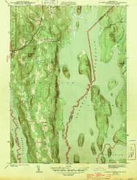
1944 Map of Quabbin Reservoir
USGS Topo · Published 1944About this map
The waters of the Quabbin Reservoir dominate this 1940s landscape, illustrating the profound transformation of central Massachusetts as it became a critical water source. The map documents the high ground remaining as islands and peninsulas, including Soapstone Hill, Mount L, and Russ Mtn, while tracing the submerged topography and new hydraulic infrastructure like the Baffle Dam. While much of the area was inundated, residual settlements such as New Salem and Cooleyville appear along the northern and western margins, providing a geographic record for those tracing family roots in the townships of Petersham, Hardwick, and New Salem. The terrain is characterized by prominent peaks like Packard Mtn and Prescott Hill that survived the valley's flooding, alongside water features like Hop Brook and the West Branch Fever Bk that continue to drain into the newly formed reservoir.
Find a feature on this map
27 named features on this map. Tap any name to fly to it.
Don’t see what you’re looking for? This feature index may not catch every label — zoom into the map to look around manually.
Map Details
Editions of this 1944 Quabbin Reservoir Map
3 editions found
Other maps of this area

1887 · Warwick
USGS Topo · 1:62,500

1887 · Belchertown
USGS Topo · 1:62,500

1887 · Winchendon
USGS Topo · 1:62,500

1887 · Barre
USGS Topo · 1:62,500

1889 · Barre
USGS Topo · 1:62,500

1889 · Warwick
USGS Topo · 1:62,500

1890 · Belchertown
USGS Topo · 1:62,500

1890 · Winchendon
USGS Topo · 1:62,500

1893 · Belchertown
USGS Topo · 1:62,500

1894 · Winchendon
USGS Topo · 1:62,500