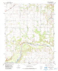
1984 Map of Quanah NE
USGS Topo · Published 1985About this map
The Red River serves as a shifting natural border in this 1980s survey, marking the Indefinite Boundary between Jackson County and Hardeman County. The landscape is defined by its agricultural and industrial utility, with Grain Bins and Storage Bins scattered across the northern sections of Eldorado and Carmel. These rural townships are linked by the tracks of the Burlington Northern railroad, which cuts through the northwest corner near several mapped Wells. Local history is anchored by the Odema Cem, while the industrial footprint of the region is evident through the Creta Mine and various Oil Wells. The terrain transitions from the low-lying basins of Mule Creek and Sandy Creek to more prominent elevations like the Butte in the northeast, illustrating the river-cut topography typical of this borderlands region.
Find a feature on this map
19 named features on this map. Tap any name to fly to it.
Don’t see what you’re looking for? This feature index may not catch every label — zoom into the map to look around manually.
Map Details
Editions of this 1984 Quanah NE Map
This is the sole edition of this map. No revisions or reprints were ever made.
Other maps of this area

1955 · Lawton
USGS Topo · 1:250,000

1958 · Elmer
USGS Topo · 1:62,500

1960 · Quanah
USGS Topo · 1:62,500

1964 · Olustee
USGS Topo · 1:24,000

1971 · Duke SW
USGS Topo · 1:24,000

1971 · Prairie Hill
USGS Topo · 1:24,000

1975 · Quanah NE
USGS Topo · 1:24,000

1975 · Quanah NW
USGS Topo · 1:24,000
1984 · Quanah East
USGS Topo · 1:24,000
1984 · Chillicothe
USGS Topo · 1:24,000