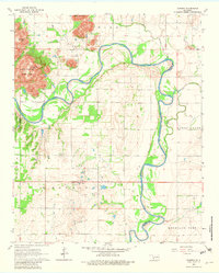
1964 Map of Warren
USGS Topo · Published 1982About this map
The North Fork Red River winds sharply through this 1964 survey, defining the border between Jackson and Kiowa counties. The landscape is dominated by the dramatic uplift of Quartz Mountain and its surrounding peaks, including Soldiers Peak and Flat Top Mountain. These granite formations provide a stark contrast to the surrounding agricultural plains, where the small community of Warren sits at a crossroads south of the river. The presence of Quartz Mountain State Park highlights the area's transition into a recreational and conservation zone during the mid-20th century. Local industry is visible through several Gravel Pits and a Quarry, while family history is marked by a lone Cem tucked away in the section lines. The map also traces the rugged path of Devils Canyon and the confluence of Tepee Creek with the Red River.
Find a feature on this map
21 named features on this map. Tap any name to fly to it.
Don’t see what you’re looking for? This feature index may not catch every label — zoom into the map to look around manually.
Map Details
Editions of this 1964 Warren Map
2 editions found
Other maps of this area

1955 · Lawton
USGS Topo · 1:250,000

1963 · Babbs
USGS Topo · 1:24,000

1964 · Altus
USGS Topo · 1:24,000

1964 · Lone Wolf
USGS Topo · 1:24,000

1964 · Warren
USGS Topo · 1:24,000

1964 · Headrick
USGS Topo · 1:24,000
1964 · Roosevelt
USGS Topo · 1:24,000

1964 · Long Mountain
USGS Topo · 1:24,000

1971 · Blair
USGS Topo · 1:24,000

1971 · Lake Altus
USGS Topo · 1:24,000