
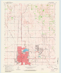
1964 Map of Altus
USGS Topo · Published 1965About this map
Altus stands as a busy regional hub in Jackson County during the mid-1960s, defined by its extensive rail infrastructure and the presence of the Altus Air Force Base. The town layout is dense with civic landmarks, including the local Courthouse, City Hall, and several educational institutions such as the Jr College and Central Jr High Sch. The intersection of three major railroads—the Atchison Topeka and Santa Fe, the Missouri - Kansas - Texas, and the St Louis - San Francisco—underscores the city's importance as a transportation nexus for the surrounding agricultural plains. Beyond the city limits, the landscape is shaped by water management features like the Altus Canal and the Aqueduct, which support the irrigation needs of the Baucum and Martha areas.
Find a feature on this map
41 named features on this map. Tap any name to fly to it.
Don’t see what you’re looking for? This feature index may not catch every label — zoom into the map to look around manually.
Map Details
Editions of this 1964 Altus Map
2 editions found
Other maps of this area

1955 · Lawton
USGS Topo · 1:250,000

1963 · Altus SE
USGS Topo · 1:24,000

1964 · Martha
USGS Topo · 1:24,000

1964 · Tipton
USGS Topo · 1:24,000

1964 · Warren
USGS Topo · 1:24,000

1964 · Olustee
USGS Topo · 1:24,000

1964 · Headrick
USGS Topo · 1:24,000

1971 · Blair
USGS Topo · 1:24,000

1971 · Hester
USGS Topo · 1:24,000

1985 · Altus
USGS Topo · 1:100,000