
1963 Map of Babbs
USGS Topo · Published 1965About this map
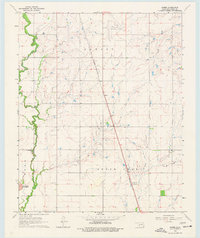
Otter Creek and its western branch dominate this landscape in southern Kiowa County during the early 1960s. The small settlement of Babbs sits at the center of the sheet, positioned along a major north-south transit corridor defined by the St Louis-San Francisco railway. The infrastructure of the era is evident in the transition from the Hobart Municipal Airport in the north to the Radio Tower Substation further south along the tracks. In the west, the winding course of Elk Creek carves through the terrain, passing near the prominent Camelback Mountain. This survey illustrates a rural Oklahoma economy at a time of early resource extraction, with active Oil Wells and a Gas Well scattered across the township, while the Hobart Country Club indicates the expansion of local social centers near the county seat.
Find a feature on this map
13 named features on this map. Tap any name to fly to it.
Don’t see what you’re looking for? This feature index may not catch every label — zoom into the map to look around manually.
Map Details
Editions of this 1963 Babbs Map
2 editions found
Other maps of this area

1949 · Cooperton
USGS Topo · 1:62,500

1955 · Lawton
USGS Topo · 1:250,000

1955 · Clinton
USGS Topo · 1:250,000

1956 · Glen Mountains
USGS Topo · 1:24,000

1956 · Rainy Mountain Creek
USGS Topo · 1:24,000

1956 · Cooperton
USGS Topo · 1:62,500

1957 · Clinton
USGS Topo · 1:250,000

1961 · Gotebo
USGS Topo · 1:62,500

1961 · Hobart
USGS Topo · 1:62,500

1964 · Lone Wolf
USGS Topo · 1:24,000