
1956 Map of Cooperton
USGS Topo · Published 1960About this map
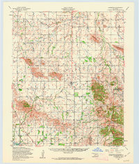
Rainy Mountain Indian Reservation land and the granite peaks of the Wichita Mountains define this mid-century landscape in southwestern Oklahoma. The settlement of Cooperton serves as a central hub, surrounded by a network of rural landmarks like the Rainy Mountain Church and Union Date Cemetery. The terrain is marked by prominent elevations such as Unap Mountain and Longhorn Mountain, while the southeastern corner reveals the protected lands of the Wichita Mountains Wildlife Refuge.
Find a feature on this map
49 named features on this map. Tap any name to fly to it.
Don’t see what you’re looking for? This feature index may not catch every label — zoom into the map to look around manually.
Map Details
Editions of this 1956 Cooperton Map
2 editions found
Other maps of this area

1937 · Cache
USGS Topo · 1:48,000

1937 · Quanah Mountain
USGS Topo · 1:24,000

1942 · Cache
USGS Topo · 1:62,500

1949 · Cooperton
USGS Topo · 1:62,500

1949 · Quanah Mountain
USGS Topo · 1:24,000

1950 · Snyder
USGS Topo · 1:62,500

1950 · Saddle Mountain
USGS Topo · 1:62,500

1955 · Lawton
USGS Topo · 1:250,000

1955 · Clinton
USGS Topo · 1:250,000

1956 · Glen Mountains
USGS Topo · 1:24,000