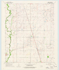
1963 Map of Babbs
USGS Topo · Published 1977About this map
Elk Creek meanders along the western edge of this Kiowa County landscape, while the St. Louis - San Francisco railroad cuts a sharp diagonal line from the northwest to the southeast. At the center of the survey lies Babbs, a small settlement positioned at the intersection of the rail line and the section roads. This mid-century view captures the transition of the rural economy, showing the presence of both a Gas Well and an Oil Well amidst the township of Otter Creek. Near the northern border, the Hobart Municipal Airport and Hobart Country Club indicate the outward expansion of the neighboring county seat. To the southwest, the terrain rises sharply at Camelback Mountain, providing a distinct topographical contrast to the more level agricultural fields and drainage patterns of West Otter Creek.
Find a feature on this map
14 named features on this map. Tap any name to fly to it.
Don’t see what you’re looking for? This feature index may not catch every label — zoom into the map to look around manually.
Map Details
Editions of this 1963 Babbs Map
2 editions found
Other maps of this area

1949 · Cooperton
USGS Topo · 1:62,500

1955 · Lawton
USGS Topo · 1:250,000

1955 · Clinton
USGS Topo · 1:250,000

1956 · Glen Mountains
USGS Topo · 1:24,000

1956 · Rainy Mountain Creek
USGS Topo · 1:24,000

1956 · Cooperton
USGS Topo · 1:62,500

1957 · Clinton
USGS Topo · 1:250,000

1961 · Gotebo
USGS Topo · 1:62,500

1961 · Hobart
USGS Topo · 1:62,500

1963 · Babbs
USGS Topo · 1:24,000