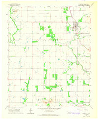
1964 Map of Roosevelt
USGS Topo · Published 1965About this map
Roosevelt serves as the primary hub of this Kiowa County landscape, situated along the St Louis - San Francisco railroad line. The mid-century town plan shows a detailed grid of streets and structures, supported by local infrastructure like the Roosevelt Cem and nearby Sewage Disposal Ponds. The surrounding countryside in the Otter Creek and Dill districts is defined by agricultural section lines and scattered rural landmarks, including the Community Ch to the southwest.
Find a feature on this map
17 named features on this map. Tap any name to fly to it.
Don’t see what you’re looking for? This feature index may not catch every label — zoom into the map to look around manually.
Map Details
Editions of this 1964 Roosevelt Map
This is the sole edition of this map. No revisions or reprints were ever made.
Other maps of this area

1949 · Cooperton
USGS Topo · 1:62,500

1950 · Snyder
USGS Topo · 1:62,500

1955 · Lawton
USGS Topo · 1:250,000

1956 · Glen Mountains
USGS Topo · 1:24,000

1956 · Snyder
USGS Topo · 1:24,000

1956 · Rainy Mountain Creek
USGS Topo · 1:24,000

1956 · Snyder
USGS Topo · 1:62,500

1956 · Cooperton
USGS Topo · 1:62,500

1963 · Babbs
USGS Topo · 1:24,000

1964 · Lone Wolf
USGS Topo · 1:24,000