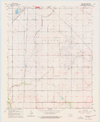
1963 Map of Altus SE
USGS Topo · Published 1976About this map
Agricultural development and complex water infrastructure define this area of Jackson County in the early 1960s. The southeastern outskirts of Altus transition into the expansive Baucum Field, where the irrigation needs of the landscape are serviced by the Altus Canal and a network of engineered siphons. This survey captures the region's transport importance, showing three major rail lines—the St Louis - San Francisco, the Atchison Topeka and Santa Fe, and the Missouri - Kansas - Texas—intersecting the grid-like township and range layout. Local history is anchored by the Elmer Cem near the southern Base Line and Francis Cem to the east, while urban utility is represented by the substation and Sewage Disposal Ponds near Lincoln Park. The map reveals a highly managed landscape where civil engineering and rail commerce shaped the rural Oklahoma plains.
Find a feature on this map
19 named features on this map. Tap any name to fly to it.
Don’t see what you’re looking for? This feature index may not catch every label — zoom into the map to look around manually.
Map Details
Editions of this 1963 Altus SE Map
2 editions found
Other maps of this area

1955 · Lawton
USGS Topo · 1:250,000

1958 · Frederick
USGS Topo · 1:62,500

1958 · Elmer
USGS Topo · 1:62,500

1963 · Altus SE
USGS Topo · 1:24,000

1964 · Martha
USGS Topo · 1:24,000

1964 · Altus
USGS Topo · 1:24,000

1964 · Tipton
USGS Topo · 1:24,000

1964 · Olustee
USGS Topo · 1:24,000

1964 · Headrick
USGS Topo · 1:24,000

1975 · Elmore City NE
USGS Topo · 1:24,000