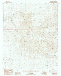
1988 Map of Quartz Peak
USGS Topo · Published 1988About this map
Peter Kane Mountain and the prominent Quartz Peak anchor this desert landscape in eastern Imperial County, where the terrain is defined by a series of deep drainage systems. The network of seasonal waterways, including Vinagre Wash, Julian Wash, and Gavilan Wash, illustrates the erosional patterns of the Colorado Desert. A notable life-sustaining feature in this arid environment is the Peter Kane Water Hole, positioned north of the main peak. Evidence of mineral exploration is scattered throughout the region, with numerous Prospects and individual Prospect sites located near Black Mountain and Indian Pass. These markings suggest a history of small-scale mining efforts typical of the late 20th-century California desert. Modern infrastructure is represented by Radio Facilities situated on the higher elevations, providing a contrast to the primitive desert trails and washes that remain the primary routes through the canyons.
Find a feature on this map
14 named features on this map. Tap any name to fly to it.
Don’t see what you’re looking for? This feature index may not catch every label — zoom into the map to look around manually.
Map Details
Editions of this 1988 Quartz Peak Map
This is the sole edition of this map. No revisions or reprints were ever made.
Other maps of this area

1903 · Yuma
USGS Topo · 1:125,000

1905 · Yuma
USGS Topo · 1:125,000

1942 · Yuma
USGS Topo · 1:250,000

1942 · Blythe
USGS Topo · 1:250,000

1945 · Picacho Peak
USGS Topo · 1:62,500

1945 · Picacho
USGS Topo · 1:62,500

1951 · Picacho
USGS Topo · 1:62,500

1951 · Picacho Peak
USGS Topo · 1:62,500

1953 · Quartz Peak
USGS Topo · 1:62,500

1953 · Ogilby
USGS Topo · 1:62,500