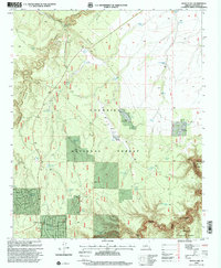
1998 Map of Quayle Hill
USGS Topo · Published 2000About this map
Coconino National Forest defines this high-desert landscape in northern Arizona, where the terrain is dominated by the deep incisions of Jacks Canyon and the prominent rise of Quayle Hill. This late-twentieth-century survey reveals a territory primarily managed for cattle and forestry, evidenced by the extensive network of livestock water sources such as Quayle Field Tank, Red Hill Tank, and the curiously named Tank In the Road. The map documents early aviation infrastructure with the Brown Landing Strip and AZ Landing Strip positioned on relatively level ground near Payne Tank.
Find a feature on this map
48 named features on this map. Tap any name to fly to it.
Don’t see what you’re looking for? This feature index may not catch every label — zoom into the map to look around manually.
Map Details
Editions of this 1998 Quayle Hill Map
This is the sole edition of this map. No revisions or reprints were ever made.
Other maps of this area

1886 · Holbrook
USGS Topo · 1:250,000

1887 · Verde
USGS Topo · 1:250,000

1892 · Verde
USGS Topo · 1:250,000

1893 · Holbrook
USGS Topo · 1:250,000

1954 · Holbrook
USGS Topo · 1:250,000

1955 · Sunset Knoll 2 SW
USGS Topo · 1:24,000

1955 · Sunset Pass
USGS Topo · 1:62,500

1957 · Holbrook
USGS Topo · 1:250,000

1958 · Holbrook
USGS Topo · 1:250,000

1960 · Holbrook
USGS Topo · 1:250,000