
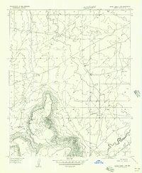
1955 Map of Sunset Knoll 2 SW
USGS Topo · Published 1957About this map
West Sunset Mountain and its eastern counterpart dominate the high-desert landscape in this mid-century survey of Coconino County. The topography is defined by the deep incision of Jacks Canyon and the winding course of Clear Creek, which carves through the southern plateau. This era of land management is heavily marked by water infrastructure essential for livestock, including Dick Hart Tank, Red Tanks, and numerous unnamed stock tanks scattered across the draws. A significant geological break occurs at Sunset Pass, where the terrain drops between the two primary mountain masses. This 1955 mapping provides a look at the remote cattle-grazing territory before modern development, recording specific topographic landmarks like East Sunset and the Stock Peaks that served as primary reference points for local ranchers and early travelers through the high Arizona desert.
Find a feature on this map
12 named features on this map. Tap any name to fly to it.
Don’t see what you’re looking for? This feature index may not catch every label — zoom into the map to look around manually.
Map Details
Editions of this 1955 Sunset Knoll 2 SW Map
This is the sole edition of this map. No revisions or reprints were ever made.
Other maps of this area

1886 · Holbrook
USGS Topo · 1:250,000

1887 · Verde
USGS Topo · 1:250,000

1892 · Verde
USGS Topo · 1:250,000

1893 · Holbrook
USGS Topo · 1:250,000

1954 · Holbrook
USGS Topo · 1:250,000
1955 · Sunset Knoll 2 NW
USGS Topo · 1:24,000

1955 · Sunset Knoll 2 SE
USGS Topo · 1:24,000

1955 · Sunset Pass
USGS Topo · 1:62,500

1957 · Holbrook
USGS Topo · 1:250,000

1958 · Holbrook
USGS Topo · 1:250,000