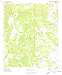
1972 Map of Queens Hill Lake
USGS Topo · Published 1974About this map
The Big Black River carves a winding boundary between Warren and Hinds counties, defining the western edge of this early 1970s landscape. This rural stretch of Mississippi is dotted with small communities like Youngton, Lynchburg, and Shiloh, linked by a network of local roads crossing numerous bridges such as BR 176. The terrain is deeply dissected by a web of tributaries including Porter Creek, Halls Creek, and Messenger Creek, creating a complex series of ridges and hollows that house several family and community landmarks.
Find a feature on this map
44 named features on this map. Tap any name to fly to it.
Don’t see what you’re looking for? This feature index may not catch every label — zoom into the map to look around manually.
Map Details
Editions of this 1972 Queens Hill Lake Map
2 editions found
Other maps of this area

1903 · Jackson
USGS Topo · 1:125,000

1934 · Raymond
USGS Topo · 1:48,000

1937 · Raymond
USGS Topo · 1:62,500

1938 · Edwards
USGS Topo · 1:62,500

1940 · Mechanicsburg
USGS Topo · 1:62,500

1942 · Raymond
USGS Topo · 1:62,500

1955 · Jackson
USGS Topo · 1:250,000

1961 · Jackson
USGS Topo · 1:250,000

1962 · Jackson
USGS Topo · 1:250,000

1962 · Flora
USGS Topo · 1:62,500