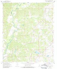
1972 Map of Queens Hill Lake
USGS Topo · Published 1986About this map
The Big Black River meanders along the western edge of this territory, forming the natural boundary between Warren and Hinds counties. The landscape is defined by its complex hydrology, featuring numerous oxbow lakes and named bayous like Adams Bayou and Horseshoe Lake that reveal the river's shifting historical course. This area in the early 1970s shows a distributed rural settlement pattern, centered around small communities like Youngton and Lynchburg. Local life is anchored by a significant network of country churches, including West Harper Ch, Good Hope Ch, and Rose Hill Ch. Genealogists and researchers will find several family-named landmarks and resting places, such as Harris Cem and Birdsong Cem, while industrial activity is represented by multiple Gravel Pits scattered near Queens Hill Lake.
Find a feature on this map
35 named features on this map. Tap any name to fly to it.
Don’t see what you’re looking for? This feature index may not catch every label — zoom into the map to look around manually.
Map Details
Editions of this 1972 Queens Hill Lake Map
2 editions found
Other maps of this area

1903 · Jackson
USGS Topo · 1:125,000

1934 · Raymond
USGS Topo · 1:48,000

1937 · Raymond
USGS Topo · 1:62,500

1938 · Edwards
USGS Topo · 1:62,500

1940 · Mechanicsburg
USGS Topo · 1:62,500

1942 · Raymond
USGS Topo · 1:62,500

1955 · Jackson
USGS Topo · 1:250,000

1961 · Jackson
USGS Topo · 1:250,000

1962 · Jackson
USGS Topo · 1:250,000

1962 · Flora
USGS Topo · 1:62,500