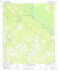
1977 Map of Queensland
USGS Topo · Published 1977About this map
The Ocmulgee River carves the northeastern boundary of this 1970s landscape, where the borders of Ben Hill, Wilcox, and Telfair counties converge. This interior Georgia terrain is defined by a network of waterways including Otter Creek, House Creek, and Deaden Branch, supporting local industry and land use. The presence of Bowens Mill and the State Fish Hatchery near the center of the sheet highlights the historical importance of these water resources. Rural life is anchored by several country churches and burial grounds, such as Evergreen Ch, Dorminy Mill Ch, and the Dixon Cem. An Old Railroad Grade cuts diagonally across the northwest, tracing a vanished transportation corridor through the wooded areas near Queensland. A prominent Lookout Tower and Radio Tower further mark the local skyline, serving as key navigational points for researchers studying the mid-twentieth-century development of the region.
Find a feature on this map
32 named features on this map. Tap any name to fly to it.
Don’t see what you’re looking for? This feature index may not catch every label — zoom into the map to look around manually.
Map Details
Editions of this 1977 Queensland Map
This is the sole edition of this map. No revisions or reprints were ever made.
Other maps of this area

1953 · Waycross
USGS Topo · 1:250,000

1958 · Waycross
USGS Topo · 1:250,000

1972 · Cooks Still
USGS Topo · 1:24,000

1972 · Fitzgerald East
USGS Topo · 1:24,000

1972 · China Hill
USGS Topo · 1:24,000

1972 · Queensland
USGS Topo · 1:24,000

1973 · Fitzgerald West
USGS Topo · 1:24,000
1974 · Abbeville South
USGS Topo · 1:24,000

1977 · Osierfield
USGS Topo · 1:24,000
1977 · Rhine
USGS Topo · 1:24,000