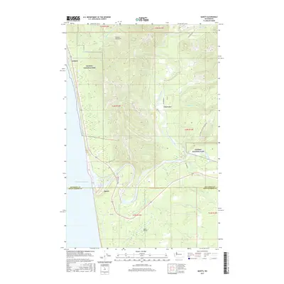
2017 Map of Queets
USGS Topo · Published 2017About this map
Queets and Kalaloch stand as the primary coastal touchpoints where the Pacific shoreline meets the dense forests of the Olympic Mountains. This 2017 survey shows a landscape heavily defined by its river systems and federal land management, with the Olympic National Park boundary bisecting the terrain. The Queets River and Clearwater River dominate the interior drainage, creating complex alluvial patterns near the coast. Transportation is anchored by Highway 101, but the interior is accessible primarily via timber and service routes like the Hoh Mainline and Nat For Dev Rd 4700. A notable geographic opening is found at Moses Prairie in the southern portion of the quadrangle, providing a rare break in the timbered hills near the Whale Cr drainage and the border between Jefferson and Grays Harbor counties.
Find a feature on this map
37 named features on this map. Tap any name to fly to it.
Don’t see what you’re looking for? This feature index may not catch every label — zoom into the map to look around manually.
Map Details
Editions of this 2017 Queets Map
This is the sole edition of this map. No revisions or reprints were ever made.
Other maps of this area

1943 · Copalis Beach
USGS Topo · 1:250,000

1951 · Copalis Beach
USGS Topo · 1:250,000

1955 · Taholah
USGS Topo · 1:62,500

1955 · Macafee Hill
USGS Topo · 1:62,500

1956 · Destruction Island
USGS Topo · 1:62,500

1956 · Salmon River
USGS Topo · 1:62,500

1957 · Copalis Beach
USGS Topo · 1:250,000

1963 · Copalis Beach
USGS Topo · 1:250,000
1980 · Copalis Beach
USGS Topo · 1:100,000
1982 · Destruction Island
USGS Topo · 1:24,000