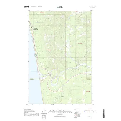
2020 Map of Queets
USGS Topo · Published 2020About this map
The Pacific Ocean coastline meets the dense river valleys of the Olympic Peninsula in this modern survey. The coastal settlement of Kalaloch stands at the edge of Olympic National Park, where Kalaloch Creek flows beneath Kalaloch Ridge. Further south, the community of Queets is positioned near the mouth of the Queets River, with Jackson Hts situated just inland. The landscape is defined by its complex drainage systems, including the Clearwater River and its various rapids, such as Preacher Rapids and Parson Rapids. Inland, the terrain opens into Moses Prairie, a distinct break from the surrounding timbered ridges. Transportation is dominated by the corridor of Highway 101 and the Old Olympic Highway, while logging and access roads like the Hoh Mainline and Nat For Dev Rd 4700 penetrate the interior forests.
Find a feature on this map
41 named features on this map. Tap any name to fly to it.
Don’t see what you’re looking for? This feature index may not catch every label — zoom into the map to look around manually.
Map Details
Editions of this 2020 Queets Map
This is the sole edition of this map. No revisions or reprints were ever made.
Other maps of this area

1943 · Copalis Beach
USGS Topo · 1:250,000

1951 · Copalis Beach
USGS Topo · 1:250,000

1955 · Taholah
USGS Topo · 1:62,500

1955 · Macafee Hill
USGS Topo · 1:62,500

1956 · Destruction Island
USGS Topo · 1:62,500

1956 · Salmon River
USGS Topo · 1:62,500

1957 · Copalis Beach
USGS Topo · 1:250,000

1963 · Copalis Beach
USGS Topo · 1:250,000
1980 · Copalis Beach
USGS Topo · 1:100,000
1982 · Destruction Island
USGS Topo · 1:24,000