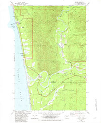
1982 Map of Queets
USGS Topo · Published 1982About this map
The Pacific Ocean coastline meets the dense river valleys of the Olympic Peninsula in this early 1980s record. The settlement of Queets sits near the mouth of the Queets River, marking the northern edge of the Quinault Indian Reservation Boundary. Further inland, the Clearwater River winds past the Queets-Clearwater Sch and the small community of Clearwater. This survey details a landscape defined by the intersection of tribal land, federal protection within Olympic National Park, and the logging-adjacent gravel economy.
Find a feature on this map
40 named features on this map. Tap any name to fly to it.
Don’t see what you’re looking for? This feature index may not catch every label — zoom into the map to look around manually.
Map Details
Editions of this 1982 Queets Map
This is the sole edition of this map. No revisions or reprints were ever made.
Other maps of this area

1943 · Copalis Beach
USGS Topo · 1:250,000

1951 · Copalis Beach
USGS Topo · 1:250,000

1955 · Taholah
USGS Topo · 1:62,500

1955 · Macafee Hill
USGS Topo · 1:62,500

1956 · Destruction Island
USGS Topo · 1:62,500

1956 · Salmon River
USGS Topo · 1:62,500

1957 · Copalis Beach
USGS Topo · 1:250,000

1963 · Copalis Beach
USGS Topo · 1:250,000
1980 · Copalis Beach
USGS Topo · 1:100,000
1982 · Destruction Island
USGS Topo · 1:24,000