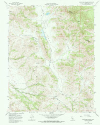
1968 Map of Quien Sabe Valley
USGS Topo · Published 1971About this map
Quien Sabe Valley and the surrounding Santa Ana Mountains dominate this high-relief landscape in the late 1960s. The map illustrates a remote ranching economy centered around the Quien Sabe Ranch and Buena Vista Ranch, connected by a network of unimproved roads and specialized infrastructure like a remote Landing Strip. The topographic detail reveals the complex drainages of Quien Sabe Creek and Santa Ana Creek, which carve through the steep terrain of Schoolhouse Ridge and Little Quien Sabe Valley. Numerous isolated springs and water tanks are marked throughout the peaks, including Potrero Peak and Reinoso Peak, underscoring the importance of water management in these coastal ranges. The presence of a prominent Grant Boundary and the poetic Cañada de las Aguilas Reales reflects the area's deep-rooted land use history and heritage.
Find a feature on this map
24 named features on this map. Tap any name to fly to it.
Don’t see what you’re looking for? This feature index may not catch every label — zoom into the map to look around manually.
Map Details
Editions of this 1968 Quien Sabe Valley Map
2 editions found
Other maps of this area

1919 · San Benito
USGS Topo · 1:62,500

1919 · Hollister
USGS Topo · 1:48,000

1921 · Gonzales
USGS Topo · 1:62,500

1921 · Hollister
USGS Topo · 1:62,500

1922 · Quien Sabe
USGS Topo · 1:62,500

1923 · Hollister
USGS Topo · 1:62,500

1931 · San Benito
USGS Topo · 1:62,500

1940 · Hollister
USGS Topo · 1:62,500

1940 · Quien Sabe
USGS Topo · 1:62,500

1940 · San Benito
USGS Topo · 1:62,500