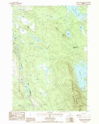
1987 Map of Quillpig Mountain
USGS Topo · Published 1988About this map
The Narraguagus River winds through the western half of this Maine interior, creating a distinct riparian corridor anchored by The Oxbow. This late 1980s terrain is defined by a dense network of brooks and isolated ponds, including the curious Twentyeight Pond and Unknown Pond, set against the elevation of Quillpig Mtn and Thirtyfive Ridge. To the east, the large expanse of Mopang Lake and its Lovejoy Cove dominate the border with Washington County. The map reflects a landscape organized by township designations like T 35 M D and Devereaux, showing the area before significant modern development altered these remote Maine timberlands and glacial waterways.
Find a feature on this map
39 named features on this map. Tap any name to fly to it.
Don’t see what you’re looking for? This feature index may not catch every label — zoom into the map to look around manually.
Map Details
Editions of this 1987 Quillpig Mountain Map
This is the sole edition of this map. No revisions or reprints were ever made.
Other maps of this area

1929 · Lead Mountain
USGS Topo · 1:48,000

1932 · Nicatous Lake
USGS Topo · 1:48,000

1932 · Lead Mountain
USGS Topo · 1:62,500

1934 · Nicatous Lake
USGS Topo · 1:62,500

1941 · Tug Mountain
USGS Topo · 1:62,500

1941 · Wabassus Lake
USGS Topo · 1:62,500

1943 · Tug Mountain
USGS Topo · 1:62,500

1943 · Wabassus Lake
USGS Topo · 1:62,500

1948 · Bangor
USGS Topo · 1:250,000

1953 · Wabassus Lake
USGS Topo · 1:62,500