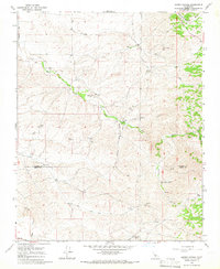
1965 Map of Quincy School
USGS Topo · Published 1966About this map
White River winds through this foothill landscape, providing a critical water source for the remote ranching operations of the mid-1960s. The presence of the Old Stockton Los Angeles Stage Road and the Quincy Sch (Site) marks the evolution of local travel and education in this sparsely settled region of the Central Valley edge. Evidence of historical exploration is anchored by the Padre Francisco Garces Historical Monument, situated near where the Tulare Co Kern Co boundary line meets Grizzly Gulch. The map details a network of water-dependent features essential to the era's economy, including the Gaging Station and several remote outposts like Flynn Ranch and Hockett Well. This topographical survey captures a landscape defined by drainage patterns like Rag Gulch and Tyler Gulch before significant modern development altered these traditional ranching lands.
Find a feature on this map
19 named features on this map. Tap any name to fly to it.
Don’t see what you’re looking for? This feature index may not catch every label — zoom into the map to look around manually.
Map Details
Editions of this 1965 Quincy School Map
2 editions found
Other maps of this area

1926 · Quincy School
USGS Topo · 1:31,680

1929 · Richgrove
USGS Topo · 1:31,680

1929 · Quincy School
USGS Topo · 1:31,680

1929 · Ducor
USGS Topo · 1:31,680

1931 · Deepwell Ranch
USGS Topo · 1:31,680

1932 · Woody
USGS Topo · 1:62,500

1935 · Woody
USGS Topo · 1:62,500

1936 · White River
USGS Topo · 1:62,500

1936 · Tobias Peak
USGS Topo · 1:125,000
1942 · Slater
USGS Topo · 1:62,500