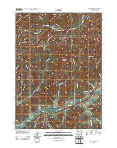
2011 Map of Quines Creek
USGS Topo · Published 2011About this map
Cow Creek flows through the southern heart of this landscape, serving as a primary corridor for transportation and settlement in Douglas County. Along its banks and the adjacent Interstate 5, several small communities and service points are established, including Azalea, Galesville, and the Cow Creek Safety Rest Area. The presence of the Azalea Post Office and the Quines Creek Cemetery indicates a long-standing local community infrastructure nestled at the base of the surrounding ridges.
Find a feature on this map
58 named features on this map. Tap any name to fly to it.
Don’t see what you’re looking for? This feature index may not catch every label — zoom into the map to look around manually.
Map Details
Editions of this 2011 Quines Creek Map
This is the sole edition of this map. No revisions or reprints were ever made.
Other maps of this area

1904 · Riddle
USGS Topo · 1:125,000

1954 · Days Creek
USGS Topo · 1:62,500

1954 · Glendale
USGS Topo · 1:62,500

1954 · Wimer
USGS Topo · 1:62,500

1954 · Canyonville
USGS Topo · 1:62,500

1955 · Medford
USGS Topo · 1:250,000

1957 · Medford
USGS Topo · 1:250,000

1958 · Medford
USGS Topo · 1:250,000
1983 · King Mountain
USGS Topo · 1:24,000
1986 · Quines Creek
USGS Topo · 1:24,000