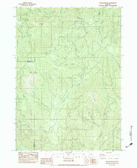
1983 Map of King Mountain
USGS Topo · Published 1983About this map
King Mountain and its surrounding peaks dominate this 1980s landscape at the intersection of Douglas, Jackson, and Josephine counties. The topography is defined by a dense network of watercourses, where Grave Creek serves as a central drainage fed by Big Boulder Creek and Starvout Creek. Evidence of industrial use is found near the heights, including multiple Borrow Pits and a Radio Facility near the peak. The high country features distinctive landmarks such as Onion Spring and Waggoner Gap, providing specific points of reference for those tracing historical land use or timber access routes. To the south, the terrain descends toward Six Prairie and Jamison Gulch, while the presence of State Highway 5 indicates the modern transportation corridor cutting through these mountains. This survey effectively documents the drainage patterns and peaks that define the rugged boundary of these three Southern Oregon counties.
Find a feature on this map
28 named features on this map. Tap any name to fly to it.
Don’t see what you’re looking for? This feature index may not catch every label — zoom into the map to look around manually.
Map Details
Editions of this 1983 King Mountain Map
This is the sole edition of this map. No revisions or reprints were ever made.
Other maps of this area

1904 · Riddle
USGS Topo · 1:125,000

1954 · Days Creek
USGS Topo · 1:62,500

1954 · Glendale
USGS Topo · 1:62,500

1954 · Wimer
USGS Topo · 1:62,500

1954 · Canyonville
USGS Topo · 1:62,500

1955 · Medford
USGS Topo · 1:250,000

1957 · Medford
USGS Topo · 1:250,000

1958 · Medford
USGS Topo · 1:250,000
1983 · Wimer
USGS Topo · 1:24,000
1983 · Skeleton Mtn
USGS Topo · 1:24,000