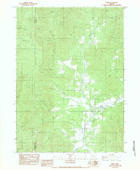
1983 Map of Wimer
USGS Topo · Published 1983About this map
Wimer serves as the primary hub in this corner of Southern Oregon, situated at the confluence of several vital watercourses. The drainage of Evans Creek and Pleasant Creek dominates the lower elevations, where the landscape is etched by irrigation works such as Fence Line Ditch and Vroman Ditch, suggesting a local economy tied to water management and agriculture. The terrain rises sharply toward the northern and western margins, marked by significant passes like China Gap and Coker Gap. To the west, the boundary between Josephine County and Jackson County bisects the drainage of Jumpoff Joe Creek. Local utility and transit are represented by the Spring Brook Airport and the Pleasant Creek Forest Station, illustrating the rural infrastructure of the early 1980s.
Find a feature on this map
26 named features on this map. Tap any name to fly to it.
Don’t see what you’re looking for? This feature index may not catch every label — zoom into the map to look around manually.
Map Details
Editions of this 1983 Wimer Map
This is the sole edition of this map. No revisions or reprints were ever made.
Other maps of this area

1904 · Riddle
USGS Topo · 1:125,000

1908 · Grants Pass
USGS Topo · 1:125,000

1954 · Glendale
USGS Topo · 1:62,500

1954 · Gold Hill
USGS Topo · 1:62,500

1954 · Wimer
USGS Topo · 1:62,500

1954 · Grants Pass
USGS Topo · 1:62,500

1955 · Medford
USGS Topo · 1:250,000

1957 · Medford
USGS Topo · 1:250,000

1958 · Medford
USGS Topo · 1:250,000
1974 · Grants Pass NE
USGS Topo · 1:24,000