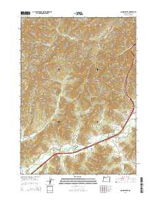
2014 Map of Quines Creek
USGS Topo · Published 2014About this map
Cow Creek and its many tributaries, including Quines Creek and Fortune Branch, carve through this Douglas County landscape where the Old Pacific Hwy and Interstate 5 dictate the modern movement of people. Small settlements like Azalea, Galesville, and Fernvale remain focal points for local history, connected by a network of rural routes such as Fernvale Rd and Murphy Rd. The topography is defined by significant elevations, including Buckhorn Mtn and the appropriately named Horse Heaven.
Find a feature on this map
62 named features on this map. Tap any name to fly to it.
Don’t see what you’re looking for? This feature index may not catch every label — zoom into the map to look around manually.
Map Details
Editions of this 2014 Quines Creek Map
This is the sole edition of this map. No revisions or reprints were ever made.
Other maps of this area

1904 · Riddle
USGS Topo · 1:125,000

1954 · Days Creek
USGS Topo · 1:62,500

1954 · Glendale
USGS Topo · 1:62,500

1954 · Wimer
USGS Topo · 1:62,500

1954 · Canyonville
USGS Topo · 1:62,500

1955 · Medford
USGS Topo · 1:250,000

1957 · Medford
USGS Topo · 1:250,000

1958 · Medford
USGS Topo · 1:250,000
1983 · King Mountain
USGS Topo · 1:24,000
1986 · Quines Creek
USGS Topo · 1:24,000