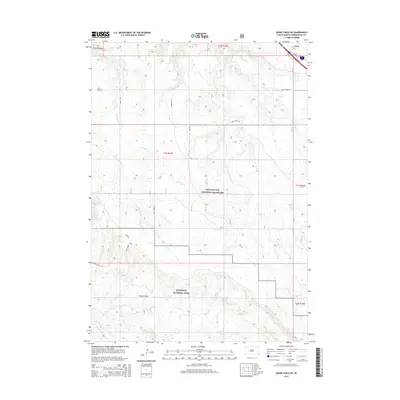
2015 Map of Quinn Table NE
USGS Topo · Published 2015About this map
Badlands National Park and the Buffalo Gap National Grassland dominate this landscape south of Wall. This survey illustrates the intricate drainage systems of the western plains, where Crooked Cr and its S Fork Crooked Cr flow through the northern sections, while Sage Cr and Middle Fork Sage Cr carve the southern Badlands terrain. The transition between the high, relatively flat tablelands and the deeply eroded national park boundaries is marked by a network of rural routes like Rim Rd and Sage Creek Rd. This environment highlights the sparse but essential road grid of Pennington County, including Slanted V Rd and 236th St, which serve the agricultural and ranching interests on the fringe of the protected grasslands.
Find a feature on this map
23 named features on this map. Tap any name to fly to it.
Don’t see what you’re looking for? This feature index may not catch every label — zoom into the map to look around manually.
Map Details
Editions of this 2015 Quinn Table NE Map
This is the sole edition of this map. No revisions or reprints were ever made.
Other maps of this area

1953 · Rapid City
USGS Topo · 1:250,000

1954 · Wasta SE
USGS Topo · 1:24,000

1954 · Wasta
USGS Topo · 1:24,000

1954 · Quinn Table
USGS Topo · 1:24,000

1955 · Hot Springs
USGS Topo · 1:250,000

1957 · Rapid City
USGS Topo · 1:250,000

1960 · Quinn Table NE
USGS Topo · 1:24,000

1960 · Wall
USGS Topo · 1:24,000

1960 · Quinn Table SE
USGS Topo · 1:24,000
1960 · Wall SW
USGS Topo · 1:24,000