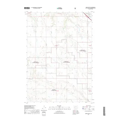
2017 Map of Quinn Table NE
USGS Topo · Published 2017About this map
Wall sits at the edge of a landscape defined by sharp elevation changes and deep seasonal watercourses in Pennington County. This 2017 topographic study highlights the complex drainage systems of the eastern edge of Badlands National Park and the expansive Buffalo Gap National Grassland. The terrain is marked by the winding paths of Sage Cr, Crooked Cr, and Bull Cr, which reveal the erosive forces characteristic of the region. Transportation and access are grounded in a network of gravel and section-line roads such as Sage Creek Rim Rd and SW Wall Rd, reflecting the sparse ranching and conservation-oriented land use of the early twenty-first century. Aviation infrastructure is present at the Wall Municipal Airport, which serves this corridor near the breaks of the Cheyenne River watershed.
Find a feature on this map
24 named features on this map. Tap any name to fly to it.
Don’t see what you’re looking for? This feature index may not catch every label — zoom into the map to look around manually.
Map Details
Editions of this 2017 Quinn Table NE Map
This is the sole edition of this map. No revisions or reprints were ever made.
Other maps of this area

1953 · Rapid City
USGS Topo · 1:250,000

1954 · Wasta SE
USGS Topo · 1:24,000

1954 · Wasta
USGS Topo · 1:24,000

1954 · Quinn Table
USGS Topo · 1:24,000

1955 · Hot Springs
USGS Topo · 1:250,000

1957 · Rapid City
USGS Topo · 1:250,000

1960 · Quinn Table NE
USGS Topo · 1:24,000

1960 · Wall
USGS Topo · 1:24,000

1960 · Quinn Table SE
USGS Topo · 1:24,000
1960 · Wall SW
USGS Topo · 1:24,000