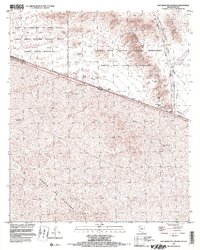
1996 Map of Quitobaquito Springs
USGS Topo · Published 2000About this map
Quitobaquito Springs and the adjacent Quitobaquito Pond serve as a critical focal point in this desert landscape straddling the international boundary. The terrain is defined by the Quitobaquito Hills and the Cipriano Hills, where scattered water sources like Williams Spring and Burro Spring provided essential stopovers for travelers. The map documents the intersection of significant land management areas, including the Organ Pipe Cactus National Monument and the Cabeza Prieta National Wildlife Refuge. South of the border in Sonora, the settlement of El Papalote sits near the Sonoita watercourse, while landmarks such as Corner Well and Hocker Well indicate historical water extraction in this arid environment. The transition from the Sierra Los Tanques to the La Abra Plain illustrates the varied topography of the borderlands.
Find a feature on this map
31 named features on this map. Tap any name to fly to it.
Don’t see what you’re looking for? This feature index may not catch every label — zoom into the map to look around manually.
Map Details
Editions of this 1996 Quitobaquito Springs Map
This is the sole edition of this map. No revisions or reprints were ever made.
Other maps of this area

1953 · Ajo
USGS Topo · 1:250,000

1954 · Sonoyta
USGS Topo · 1:250,000

1957 · Ajo
USGS Topo · 1:250,000

1958 · Ajo
USGS Topo · 1:250,000

1962 · Ajo
USGS Topo · 1:250,000

1963 · Ajo
USGS Topo · 1:250,000

1963 · Lukeville
USGS Topo · 1:62,500

1963 · Quitobaquito Springs
USGS Topo · 1:62,500

1963 · Kino Peak
USGS Topo · 1:62,500

1963 · Lukeville
USGS Topo · 1:250,000