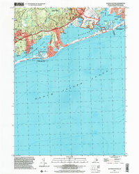
2001 Map of Quonochontaug
USGS Topo · Published 2003About this map
Quonochontaug Pond and Ninigret Pond dominate this coastal landscape, separated from Block Island Sound by narrow barrier beaches and the Quonochontaug Breachway State Fishing Area. At the turn of the millennium, the area reflects a deeply preserved maritime and recreational character, with extensive public lands including Burlingame State Park and the Ninigret National Wildlife Refuge. Coastal settlements such as Shelter Harbor, Quonochontaug, and Haversham are clearly defined, tucked between the marshes and salt ponds. Notable landmarks like the Drive-In Theater and Boys Camp provide evidence of the region's mid-century recreational history, while the numerous islands within the ponds, such as Heather Island and Governors Island, illustrate the complex shoreline and tidal environment of southern Rhode Island.
Find a feature on this map
54 named features on this map. Tap any name to fly to it.
Don’t see what you’re looking for? This feature index may not catch every label — zoom into the map to look around manually.
Map Details
Editions of this 2001 Quonochontaug Map
This is the sole edition of this map. No revisions or reprints were ever made.
Other maps of this area

1889 · Stonington
USGS Topo · 1:62,500

1889 · Charlestown
USGS Topo · 1:62,500

1889 · Block Island
USGS Topo · 1:62,500

1893 · Stonington
USGS Topo · 1:62,500

1894 · Block Island
USGS Topo · 1:62,500

1899 · Block Island
USGS Topo · 1:62,500

1904 · Montauk
USGS Topo · 1:62,500

1919 · Charlestown
USGS Topo · 1:62,500

1921 · Charlestown
USGS Topo · 1:62,500

1921 · Stonington
USGS Topo · 1:62,500