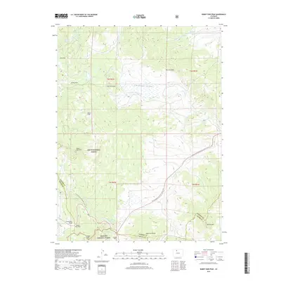
2019 Map of Rabbit Ears Peak
USGS Topo · Published 2019About this map
Rabbit Ears Peak stands as the primary landmark of this high-altitude landscape along the border of Jackson and Grand Counties. The geography is defined by the Continental Divide, where the waters of the Colorado Cr begin their long journey westward while the Grizzly Cr and Muddy Cr systems drain the surrounding slopes. The map details the convergence of the Routt National Forest and Arapaho National Forest, highlighting a network of natural basins like Cloverleaf Valley and Willow Park. Key transit points are clearly marked, including Rabbit Ears Pass and Muddy Pass, providing context for historical movement through these gaps in the Rabbit Ears Range. From the high summit of Baker Mtn to the water-management features of Bear Park Reservoir and McGowan Reservoir, the sheet reveals how this mountain environment is both a protected wilderness and a vital watershed.
Find a feature on this map
34 named features on this map. Tap any name to fly to it.
Don’t see what you’re looking for? This feature index may not catch every label — zoom into the map to look around manually.
Map Details
Editions of this 2019 Rabbit Ears Peak Map
This is the sole edition of this map. No revisions or reprints were ever made.
Other maps of this area

1911 · Hahns Peak
USGS Topo · 1:125,000

1913 · Hahns Peak
USGS Topo · 1:125,000

1954 · Craig
USGS Topo · 1:250,000

1955 · Buffalo Pass
USGS Topo · 1:24,000

1955 · Teal Lake
USGS Topo · 1:24,000

1955 · Coalmont
USGS Topo · 1:24,000

1955 · Mount Ethel
USGS Topo · 1:62,500

1955 · Walden
USGS Topo · 1:62,500

1956 · Rabbit Ears Peak
USGS Topo · 1:24,000

1956 · Lake Agnes
USGS Topo · 1:24,000