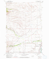
1976 Map of Racetrack
USGS Topo · Published 1981About this map
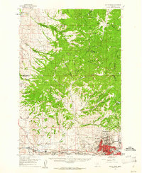
Morrison Gulch carves through the high terrain of the western slope in this 1967 field-checked study of Powell County. The landscape is defined by its dramatic elevation changes and sparse human footprint, typical of the Montana backcountry during the mid-twentieth century. Settlement in this area is minimal, centered primarily around the Perkins Ranch, which sits near the headwaters of the drainage system. The map serves as a detailed record of the drainage patterns and physical topography of the region, documenting the Morrison Gulch corridor before modern developments or shifts in land management altered the character of these ranchlands.
Find a feature on this map
2 named features on this map. Tap any name to fly to it.
Don’t see what you’re looking for? This feature index may not catch every label — zoom into the map to look around manually.
Map Details
Editions of this 1976 Racetrack Map
This is the sole edition of this map. No revisions or reprints were ever made.
Other maps of this area

1889 · Helena
USGS Topo · 1:250,000

1893 · Helena
USGS Topo · 1:250,000

1899 · Helena
USGS Topo · 1:250,000

1903 · Helena
USGS Topo · 1:250,000

1947 · Butte
USGS Topo · 1:250,000

1958 · Butte
USGS Topo · 1:250,000
1959 · Butte North
USGS Topo · 1:62,500

1959 · Deer Lodge
USGS Topo · 1:62,500

1960 · Butte
USGS Topo · 1:250,000
1961 · Anaconda
USGS Topo · 1:62,500