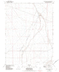
1982 Map of Ragged Top Mtn SW
USGS Topo · Published 1982About this map
Granite Springs Valley and Copper Valley define the arid landscape of this 1982 Nevada study, showing the high-desert terrain of Pershing County. The map documents sparse but vital human footprints in this desert environment, specifically the Blue Wing Cow Camp and the West Ragged Top Well located near the northern edge. These features, along with a solitary Borrow Pit, suggest the area's primary functions involved seasonal ranching and road maintenance. The natural drainage of Sage Hen Wash cuts through the valley floor, illustrating the basin-and-range topography where water is a rare and localized resource. This map is particularly useful for understanding the historical land use and water management of these remote Nevada valleys during the early 1980s.
Find a feature on this map
7 named features on this map. Tap any name to fly to it.
Don’t see what you’re looking for? This feature index may not catch every label — zoom into the map to look around manually.
Map Details
Editions of this 1982 Ragged Top Mtn SW Map
This is the sole edition of this map. No revisions or reprints were ever made.
Other maps of this area

1886 · Granite Range
USGS Topo · 1:250,000

1890 · Wadsworth
USGS Topo · 1:125,000

1892 · Wadsworth
USGS Topo · 1:125,000

1894 · Granite Range
USGS Topo · 1:250,000

1894 · Wadsworth
USGS Topo · 1:125,000

1908 · Carson Sink
USGS Topo · 1:250,000

1910 · Carson Sink
USGS Topo · 1:250,000

1931 · Lovelock
USGS Topo · 1:250,000

1935 · Lovelock
USGS Topo · 1:250,000

1951 · Desert Peak
USGS Topo · 1:62,500