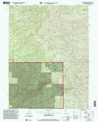
1995 Map of Raglin Ridge
USGS Topo · Published 2001About this map
The Mendocino National Forest defines the southern half of this landscape, where steep topography is carved by the North Fork Elder Creek and South Fork Cottonwood Creek. Human history in these high ridges is marked by isolated homesteads and resource extraction, with locations such as Hammer Place, Mary Ellen Place, and Copple Place anchoring the remote terrain. The presence of the Grau Mine and a simple Mine near Franklin Point indicates the area's geological prospecting history. High-elevation flats like Secret Flat and Last Feed Flat suggest seasonal grazing patterns between the prominent spine of Whisky Ridge and Elkhorn Ridge. This 1990s revision preserves the traces of early access, including the Lanyan Trail and Sunflower Trail, which provided essential routes through the drainage systems of Grizzly Creek and Dry Creek.
Find a feature on this map
46 named features on this map. Tap any name to fly to it.
Don’t see what you’re looking for? This feature index may not catch every label — zoom into the map to look around manually.
Map Details
Editions of this 1995 Raglin Ridge Map
This is the sole edition of this map. No revisions or reprints were ever made.
Other maps of this area

1890 · Red Bluff
USGS Topo · 1:250,000

1894 · Red Bluff
USGS Topo · 1:250,000

1949 · Colyear Springs
USGS Topo · 1:62,500

1952 · Paskenta
USGS Topo · 1:62,500

1952 · Anthony Peak
USGS Topo · 1:62,500

1954 · Yolla Bolly
USGS Topo · 1:62,500

1957 · Colyear Springs
USGS Topo · 1:62,500

1957 · Ukiah
USGS Topo · 1:250,000

1958 · Redding
USGS Topo · 1:250,000

1960 · Ukiah
USGS Topo · 1:250,000