
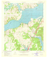
1962 Map of Raiford
USGS Topo · Published 1963About this map
The North Canadian River defines the northern edge of this McIntosh County landscape in the early 1960s, just as the Eufaula Reservoir was beginning to reshape the drainage basins. The small community of Raiford sits in the southern portion of the map, serving as a focal point for the surrounding rural area. Local history is anchored at the Lenna Sch Cem, which marks a significant site for genealogists tracking family roots in this region.
Find a feature on this map
18 named features on this map. Tap any name to fly to it.
Don’t see what you’re looking for? This feature index may not catch every label — zoom into the map to look around manually.
Map Details
Editions of this 1962 Raiford Map
This is the sole edition of this map. No revisions or reprints were ever made.
Other maps of this area

1900 · Canadian
USGS Topo · 1:125,000

1946 · Fort Smith
USGS Topo · 1:250,000

1962 · Henryetta
USGS Topo · 1:24,000

1962 · Henryetta SW
USGS Topo · 1:24,000

1962 · Pierce
USGS Topo · 1:24,000

1962 · Hoffman
USGS Topo · 1:24,000

1963 · Stidham
USGS Topo · 1:24,000

1965 · Fort Smith
USGS Topo · 1:250,000

1967 · Fort Smith
USGS Topo · 1:250,000
1971 · Canadian
USGS Topo · 1:24,000