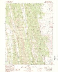
1989 Map of Rail Canyon
USGS Topo · Published 1989About this map
Clark Valley defines the central axis of this northern California landscape, where the South Fork Clark Valley Creek follows a narrow corridor between steep ridgelines. The terrain is marked by prominent natural boundaries and elevations, notably Needham Ridge to the west and the height of High Peak overlooking the eastern canyons. Water is the primary architect of the area's geography, with seasonal drainages like Hubbard Valley Creek and Fillippi Creek carving into the hills.
Find a feature on this map
23 named features on this map. Tap any name to fly to it.
Don’t see what you’re looking for? This feature index may not catch every label — zoom into the map to look around manually.
Map Details
Editions of this 1989 Rail Canyon Map
2 editions found
Other maps of this area

1904 · Logan Creek
USGS Topo · 1:24,000

1904 · Sites
USGS Topo · 1:24,000

1917 · Kurand
USGS Topo · 1:31,680

1917 · Sites
USGS Topo · 1:31,680

1918 · Logan Creek
USGS Topo · 1:31,680

1919 · Fruto
USGS Topo · 1:62,500

1919 · Elk Creek
USGS Topo · 1:62,500

1943 · Lodoga
USGS Topo · 1:62,500

1944 · Fruto
USGS Topo · 1:62,500

1948 · Elk Creek
USGS Topo · 1:62,500