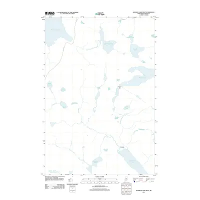
2011 Map of Rainbow Lake West
USGS Topo · Published 2011About this map
Nahmakanta Lake Camps serves as the primary human footprint in this corner of Piscataquis County, situated along the northern shore of Nahmakanta Lake. The landscape is dominated by a dense network of glacial water bodies and interconnecting waterways, including the large reach of Chesuncook Lake in the northwest and the expansive Rainbow Lake to the east. The drainage pattern is complex, with Chesuncook Stream and Bean Brook winding through low-lying areas punctuated by smaller basins like Chesuncook Pond and the Murphy Ponds. Infrastructure is minimal, represented by the Rainbow Lake Dam and the unpaved corridors of Lily Bay Rd and Telos Rd, which provide the only overland access to these remote timberlands and sporting destinations.
Find a feature on this map
36 named features on this map. Tap any name to fly to it.
Don’t see what you’re looking for? This feature index may not catch every label — zoom into the map to look around manually.
Map Details
Editions of this 2011 Rainbow Lake West Map
This is the sole edition of this map. No revisions or reprints were ever made.
Other maps of this area

1952 · Jo-Mary Mountain
USGS Topo · 1:62,500

1952 · First Roach Pond
USGS Topo · 1:62,500

1954 · Grant Farm
USGS Topo · 1:62,500

1954 · Harrington Lake
USGS Topo · 1:62,500

1954 · Millinocket
USGS Topo · 1:250,000

1958 · Millinocket
USGS Topo · 1:250,000

1960 · Millinocket
USGS Topo · 1:250,000
1978 · Rainbow Lake West
USGS Topo · 1:24,000
1978 · Caribou Lake South
USGS Topo · 1:24,000
1978 · Wadleigh Mountain
USGS Topo · 1:24,000